Class information for: |
Basic class information |
| Class id | #P | Avg. number of references |
Database coverage of references |
|---|---|---|---|
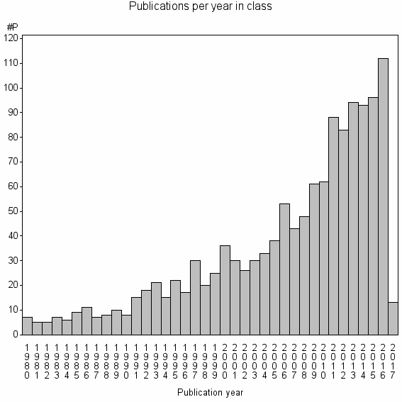
| 7991 | 1305 | 40.2 | 44% |
Hierarchy of classes |
The table includes all classes above and classes immediately below the current class. |
| Cluster id | Level | Cluster label | #P |
|---|---|---|---|
| 4 | 4 | ENVIRONMENTAL SCIENCES//GEOSCIENCES, MULTIDISCIPLINARY//METEOROLOGY & ATMOSPHERIC SCIENCES | 1766162 |
| 65 | 3 | SOIL SCIENCE//SOIL SCIENCE SOCIETY OF AMERICA JOURNAL//GEODERMA | 84825 |
| 1637 | 2 | DIGITAL SOIL MAPPING//GEODERMA//SOIL SCIENCE | 6959 |
| 7991 | 1 | DIGITAL SOIL MAPPING//SOIL SURVEY//GEODERMA | 1305 |
Terms with highest relevance score |
| rank | Term | termType | Chi square | Shr. of publ. in class containing term |
Class's shr. of term's tot. occurrences |
#P with term in class |
|---|---|---|---|---|---|---|
| 1 | DIGITAL SOIL MAPPING | authKW | 1946984 | 10% | 62% | 135 |
| 2 | SOIL SURVEY | authKW | 688770 | 6% | 40% | 73 |
| 3 | GEODERMA | journal | 405870 | 23% | 6% | 305 |
| 4 | SOIL LANDSCAPE MODEL | authKW | 402204 | 1% | 90% | 19 |
| 5 | SOIL MAPPING | authKW | 325214 | 3% | 32% | 43 |
| 6 | REGRESSION KRIGING | authKW | 323468 | 3% | 35% | 39 |
| 7 | PEDOMETRICS | authKW | 316304 | 2% | 52% | 26 |
| 8 | TERRAIN ATTRIBUTES | authKW | 207952 | 2% | 44% | 20 |
| 9 | GLOBALSOILMAP | authKW | 189515 | 1% | 90% | 9 |
| 10 | PREDICTIVE SOIL MAPPING | authKW | 187177 | 1% | 100% | 8 |
Web of Science journal categories |
| Rank | Term | Chi square | Shr. of publ. in class containing term |
Class's shr. of term's tot. occurrences |
#P with term in class |
|---|---|---|---|---|---|
| 1 | Soil Science | 122468 | 58% | 1% | 751 |
| 2 | Geography, Physical | 4125 | 10% | 0% | 126 |
| 3 | Geosciences, Multidisciplinary | 2567 | 17% | 0% | 223 |
| 4 | Geography | 1305 | 5% | 0% | 63 |
| 5 | Water Resources | 1014 | 8% | 0% | 105 |
| 6 | Remote Sensing | 910 | 4% | 0% | 49 |
| 7 | Agriculture, Multidisciplinary | 424 | 4% | 0% | 54 |
| 8 | Environmental Sciences | 316 | 9% | 0% | 121 |
| 9 | Imaging Science & Photographic Technology | 271 | 2% | 0% | 29 |
| 10 | Agronomy | 191 | 4% | 0% | 50 |
Address terms |
| Rank | Term | Chi square | Shr. of publ. in class containing term |
Class's shr. of term's tot. occurrences |
#P with term in class |
|---|---|---|---|---|---|
| 1 | FD HOLE SOILS | 108874 | 1% | 42% | 11 |
| 2 | USARQ | 76567 | 0% | 55% | 6 |
| 3 | STATE ENVIRONM OURCES INFORMAT SYST | 64988 | 0% | 56% | 5 |
| 4 | DEP GEOL METEOROL | 46794 | 0% | 100% | 2 |
| 5 | EXPLORAT HYDROCARBON | 46794 | 0% | 100% | 2 |
| 6 | MILIEU PHYS ENVIRONM | 46794 | 0% | 100% | 2 |
| 7 | AUSTRALIAN PRECIS AGR | 38662 | 1% | 18% | 9 |
| 8 | CRUO | 35093 | 0% | 50% | 3 |
| 9 | GEOSPATIAL UNIT | 35093 | 0% | 50% | 3 |
| 10 | ARID ZONE MANAGEMENT | 31195 | 0% | 67% | 2 |
Journals |
| Rank | Term | Chi square | Shr. of publ. in class containing term |
Class's shr. of term's tot. occurrences |
#P with term in class |
|---|---|---|---|---|---|
| 1 | GEODERMA | 405870 | 23% | 6% | 305 |
| 2 | EUROPEAN JOURNAL OF SOIL SCIENCE | 27263 | 4% | 3% | 46 |
| 3 | SOIL SCIENCE SOCIETY OF AMERICA JOURNAL | 25676 | 8% | 1% | 101 |
| 4 | SOIL RESEARCH | 17379 | 1% | 4% | 19 |
| 5 | CATENA | 16381 | 4% | 1% | 48 |
| 6 | REVISTA BRASILEIRA DE CIENCIA DO SOLO | 9291 | 2% | 1% | 30 |
| 7 | GEOMORPHOLOGY | 8146 | 3% | 1% | 43 |
| 8 | JOURNAL OF SOIL SCIENCE | 7866 | 1% | 2% | 17 |
| 9 | INTERNATIONAL JOURNAL OF GEOGRAPHICAL INFORMATION SCIENCE | 6397 | 2% | 1% | 20 |
| 10 | EURASIAN SOIL SCIENCE | 6266 | 2% | 1% | 29 |
Author Key Words |
| Rank | Term | Chi square | Shr. of publ. in class containing term |
Class's shr. of term's tot. occurrences |
#P with term in class |
LCSH search | Wikipedia search |
|---|---|---|---|---|---|---|---|
| 1 | DIGITAL SOIL MAPPING | 1946984 | 10% | 62% | 135 | Search DIGITAL+SOIL+MAPPING | Search DIGITAL+SOIL+MAPPING |
| 2 | SOIL SURVEY | 688770 | 6% | 40% | 73 | Search SOIL+SURVEY | Search SOIL+SURVEY |
| 3 | SOIL LANDSCAPE MODEL | 402204 | 1% | 90% | 19 | Search SOIL+LANDSCAPE+MODEL | Search SOIL+LANDSCAPE+MODEL |
| 4 | SOIL MAPPING | 325214 | 3% | 32% | 43 | Search SOIL+MAPPING | Search SOIL+MAPPING |
| 5 | REGRESSION KRIGING | 323468 | 3% | 35% | 39 | Search REGRESSION+KRIGING | Search REGRESSION+KRIGING |
| 6 | PEDOMETRICS | 316304 | 2% | 52% | 26 | Search PEDOMETRICS | Search PEDOMETRICS |
| 7 | TERRAIN ATTRIBUTES | 207952 | 2% | 44% | 20 | Search TERRAIN+ATTRIBUTES | Search TERRAIN+ATTRIBUTES |
| 8 | GLOBALSOILMAP | 189515 | 1% | 90% | 9 | Search GLOBALSOILMAP | Search GLOBALSOILMAP |
| 9 | PREDICTIVE SOIL MAPPING | 187177 | 1% | 100% | 8 | Search PREDICTIVE+SOIL+MAPPING | Search PREDICTIVE+SOIL+MAPPING |
| 10 | SOLIM | 157926 | 1% | 75% | 9 | Search SOLIM | Search SOLIM |
Core articles |
The table includes core articles in the class. The following variables is taken into account for the relevance score of an article in a cluster c: (1) Number of references referring to publications in the class. (2) Share of total number of active references referring to publications in the class. (3) Age of the article. New articles get higher score than old articles. (4) Citation rate, normalized to year. |
| Rank | Reference | # ref. in cl. |
Shr. of ref. in cl. |
Citations |
|---|---|---|---|---|
| 1 | MINASNY, B , MCBRATNEY, AB , (2016) DIGITAL SOIL MAPPING: A BRIEF HISTORY AND SOME LESSONS.GEODERMA. VOL. 264. ISSUE . P. 301 -311 | 58 | 65% | 13 |
| 2 | NAUMAN, TW , THOMPSON, JA , (2014) SEMI-AUTOMATED DISAGGREGATION OF CONVENTIONAL SOIL MAPS USING KNOWLEDGE DRIVEN DATA MINING AND CLASSIFICATION TREES.GEODERMA. VOL. 213. ISSUE . P. 385 -399 | 44 | 81% | 19 |
| 3 | SILVA, SHG , DE MENEZES, MD , OWENS, PR , CURI, N , (2016) RETRIEVING PEDOLOGIST'S MENTAL MODEL FROM EXISTING SOIL MAP AND COMPARING DATA MINING TOOLS FOR REFINING A LARGER AREA MAP UNDER SIMILAR ENVIRONMENTAL CONDITIONS IN SOUTHEASTERN BRAZIL.GEODERMA. VOL. 267. ISSUE . P. 65 -77 | 49 | 78% | 0 |
| 4 | KNUDBY, A , HEUNG, B , HO, HC , ZHANG, J , BULMER, CE , SCHMIDT, MG , (2016) AN OVERVIEW AND COMPARISON OF MACHINE-LEARNING TECHNIQUES FOR CLASSIFICATION PURPOSES IN DIGITAL SOIL MAPPING.GEODERMA. VOL. 265. ISSUE . P. 62 -77 | 47 | 59% | 5 |
| 5 | MCBRATNEY, AB , SANTOS, MLM , MINASNY, B , (2003) ON DIGITAL SOIL MAPPING.GEODERMA. VOL. 117. ISSUE 1-2. P. 3-52 | 72 | 37% | 781 |
| 6 | NAUMAN, TW , THOMPSON, JA , RASMUSSEN, C , (2014) SEMI-AUTOMATED DISAGGREGATION OF A CONVENTIONAL SOIL MAP USING KNOWLEDGE DRIVEN DATA MINING AND RANDOM FORESTS IN THE SONORAN DESERT, USA.PHOTOGRAMMETRIC ENGINEERING AND REMOTE SENSING. VOL. 80. ISSUE 4. P. 353-366 | 44 | 81% | 2 |
| 7 | ADHIKARI, K , MINASNY, B , GREVE, MB , GREVE, MH , (2014) CONSTRUCTING A SOIL CLASS MAP OF DENMARK BASED ON THE FAO LEGEND USING DIGITAL TECHNIQUES.GEODERMA. VOL. 214. ISSUE . P. 101-113 | 29 | 88% | 19 |
| 8 | KEMPEN, B , BRUS, DJ , STOORVOGEL, JJ , HEUVELINK, GBM , DE VRIES, F , (2012) EFFICIENCY COMPARISON OF CONVENTIONAL AND DIGITAL SOIL MAPPING FOR UPDATING SOIL MAPS.SOIL SCIENCE SOCIETY OF AMERICA JOURNAL. VOL. 76. ISSUE 6. P. 2097-2115 | 42 | 65% | 12 |
| 9 | BREVIK, EC , CALZOLARI, C , MILLER, BA , PEREIRA, P , KABALA, C , BAUMGARTEN, A , JORDAN, A , (2016) SOIL MAPPING, CLASSIFICATION, AND PEDOLOGIC MODELING: HISTORY AND FUTURE DIRECTIONS.GEODERMA. VOL. 264. ISSUE . P. 256 -274 | 47 | 30% | 14 |
| 10 | ODGERS, NP , SUN, W , MCBRATNEY, AB , MINASNY, B , CLIFFORD, D , (2014) DISAGGREGATING AND HARMONISING SOIL MAP UNITS THROUGH RESAMPLED CLASSIFICATION TREES.GEODERMA. VOL. 214. ISSUE . P. 91-100 | 25 | 93% | 18 |
Classes with closest relation at Level 1 |